Interactive Tools
Interactive tools transform operational cryosphere data — from satellites, weather stations and field networks — into understandable and practical insights that enable timely decision-making. These platforms bridge the gap between "raw" data and practical action: they provide the ability to monitor current conditions, forecast changes and implement adaptive strategies that increase resilience and inform evidence-based policy. In Central Asia, local solutions (SnowMapper CA, MODSNOW, CAMON, etc.) are already successfully used, and now regional specialists can access a global network of interactive tools for working with glacier, snow, permafrost and hydro-cryosphere data — at the resolution and format needed for research, planning and risk management. Following stakeholder needs assessment and focusing on innovative knowledge exchange within IW:Learn, we collaborated with international and national agencies to integrate APIs, real-time data streams and best visualization practices. Whether you're a researcher seeking the latest glacier mass balance data, a policymaker developing climate strategies, or a student diving into cryosphere science, this portal provides everything you need. Start exploring today!
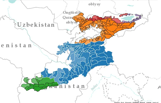
SnowMapper Central Asia
The SnowMapper Central Asia web-interactive platform provides crucial operational monitoring of snow cover in the mountainous regions of Central Asia, utilizing high-resolution analysis to track snow dynamics. It is highly relevant for the region's water resource management, offering daily 500m resolution snow data for key mountain ranges like the Tian Shan and Pamirs and allowing comparison of current conditions against a 24-year historical baseline.
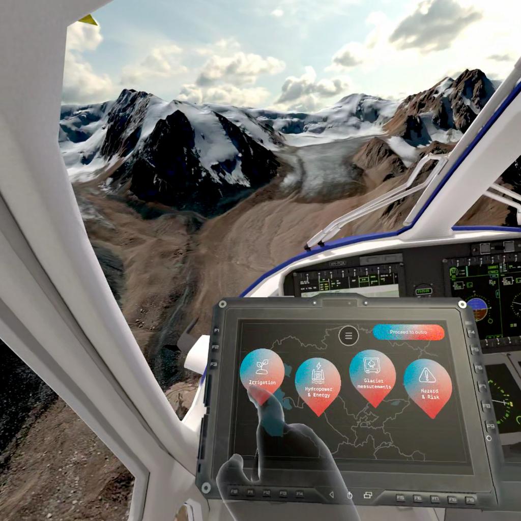
Knowledge Hub: VR-project Glacier Lifelines
Glacier Lifelines is a virtual reality (VR) experience developed by the Zurich University of the Arts under the GEF–UNDP–UNESCO Cryosphere Project. It takes users on an immersive journey through the mountains of Central Asia, exploring glaciers and the impacts of climate change. The accompanying Knowledge Hub provides the scientific background, data, and story behind the Glacier Lifelines experience — offering deeper insight into the cryosphere of Central Asia and the research that inspired the VR project.
WGMS (World Glacier Monitoring Service)
Global authority for standardized glacier data, compiling information from over 130 years of observations into comprehensive databases. For Central Asia, it provides critical long-term records for reference glaciers like Abramov and Golubin, which are essential for regional climate change assessment and water resource management.
Global Terrestrial Network for Permafrost (GTN-P)
The Global Terrestrial Network for Permafrost (GTN-P) delivers standardized permafrost temperature and active layer monitoring data, with annual thaw depth and continuous borehole temperature records from hundreds of sites worldwide. GTN-P Active Layers and GTN-P Boreholes together provide comprehensive permafrost monitoring through >274 active layer measurement sites and >1,074 temperature boreholes globally, with Central Asia covered by 6 active layer grids and ~46 boreholes for tracking permafrost dynamics and thermal conditions. But the limited site density south of 40°N restricts comprehensive regional permafrost mapping.
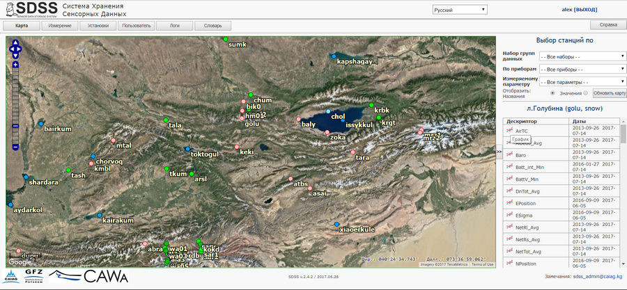
Sensor Data Storage System (SDSS)
This is a web-based platform for storing, managing, and visualising hydrological and meteorological data from monitoring stations in Central Asia, as well as water level data for numerous rivers and water bodies in Asia, Africa, and South America derived from satellite altimetry. Developed by the Central Asian Institute for Applied Geosciences (CAIAG) with the active involvement of the GFZ German Research Centre for Geosciences, initially under the CAWa project, the platform provides open access to a wide range of time series via map-based or tabular selection. Users can generate graphs and download data. SDSS supports a multilingual interface and integrates ground-based measurements with satellite data, supporting scientific research and the practical use of climate information.
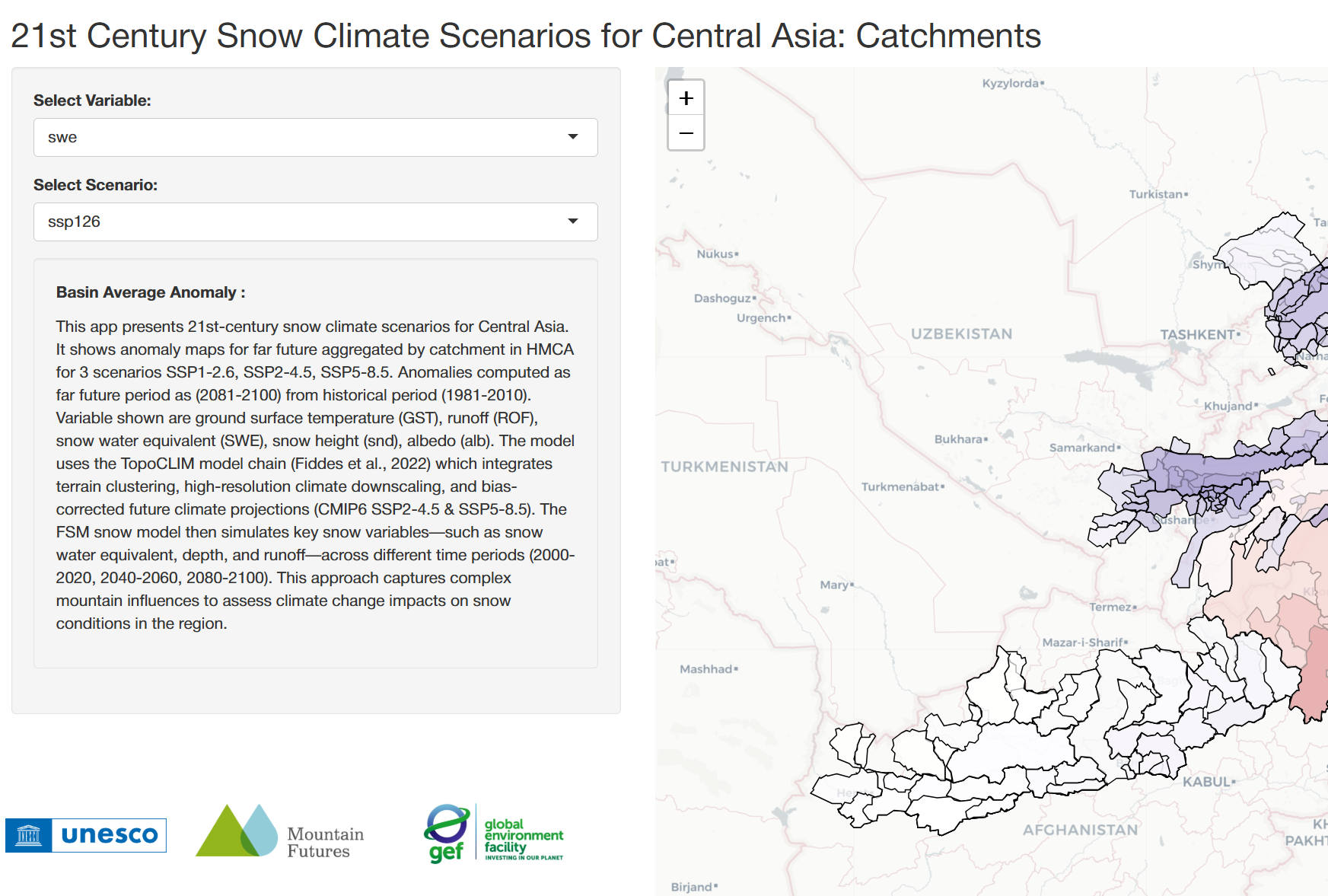
Snow Anomaly Atlas
Developed under the GEF-UNDP-UNESCO Cryosphere Project, this tool provides a spatial perspective on modelled climate impacts. Users can explore maps showing projected anomalies of key variables relative to a historical baseline, such as reductions in Snow Water Equivalent (SWE) or albedo under different climate scenarios and time horizons. These visualisations highlight regional differences in vulnerability and help identify which parts of Central Asia are most affected by declining snow resources.
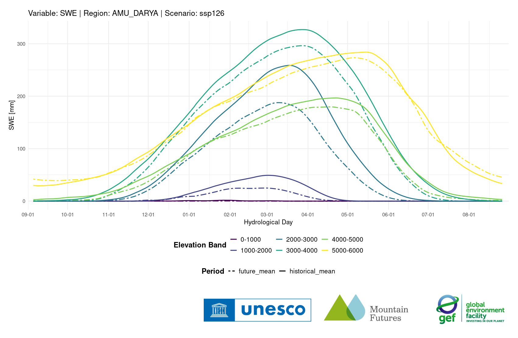
Snow Climate Scenario Explorer
Developed under the GEF-UNDP-UNESCO Cryosphere Project, this tool provides interactive visualisations of the seasonal evolution of key snow parameters, including Snow Water Equivalent (SWE), snow depth (HS), runoff (ROF), and albedo. Users can select a variable, river basin (such as the Amu Darya or Syr Darya), elevation band, and climate scenario to explore how seasonal snow dynamics are projected to change throughout the 21st century.
NASA Earthdata's Cryosphere Toolset
NASA Earthdata's Cryosphere Toolset offers unprecedented capabilities for monitoring cryospheric dynamics in Central Asia, with particular strength in snow monitoring, glacier mass balance, and permafrost dynamics. The combination of real-time operational systems (FLDAS Central Asia) with high-precision measurement platforms (ICESat-2, GRACE-FO) delivers optimal coverage for regional climate and water assessments. This comprehensive suite includes MODIS/VIIRS snow products, SMAP freeze/thaw data, GLIMS glacier inventory, and interactive visualization tools like Worldview and AppEEARS.
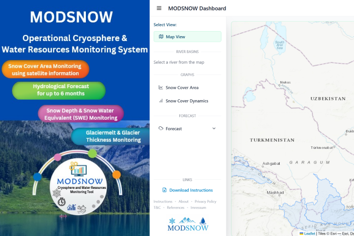
MODSNOW: Cryosphere and Water Resources Monitoring in Central Asia
The MODSNOW system, developed specifically for mountainous regions such as Central Asia, provides valuable data on water resource availability to support informed decision-making. Officially adopted by all five National Hydrometeorological Services of Central Asia, it consists of four modules that can operate independently or in combination. The system has also been implemented in Nepal and Pakistan to strengthen cryosphere and water resource monitoring in South Asia. In addition to its operational use, MODSNOW has supported numerous scientific studies, resulting in more than 20 peer-reviewed journal publications. The MODSNOW runs on any computer and functions automatically without user interaction to assure sustainable operation and continuous monitoring of water resources in Central Asia.
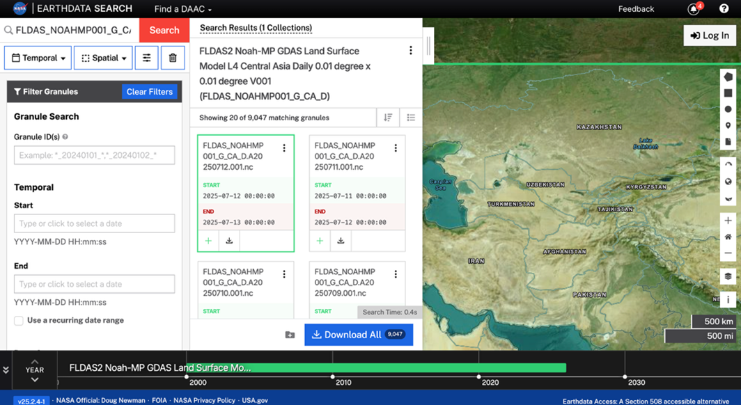
NASA FLDAS Central Asia
FLDAS Central Asia represents a purpose-built hydrological monitoring system specifically designed for the Central Asia domain (30-100°E, 21-56°N). The system operates at 1 km spatial resolution with daily temporal output and ~1-day latency using the Noah-MP (version 4.0.1) land surface model within NASA's Land Information System. FLDAS provides 27 hydrological parameters including snow water equivalent, soil moisture, runoff, and freeze/thaw indicators, with outputs available from October 2000 to present. The system uses GDAS meteorological forcing data and provides both preliminary and final runs with different forcing datasets.
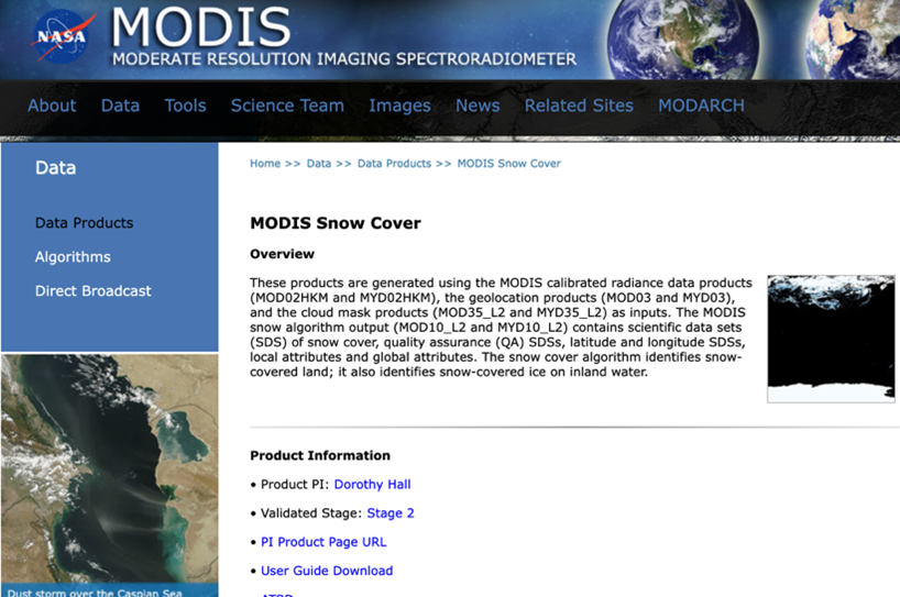
MODIS Snow Cover
MODIS snow cover products utilize the Normalized Difference Snow Index (NDSI) algorithm with overall accuracy of approximately 93% for snow detection across global landscapes. The system provides daily global coverage at 500m resolution with multiple temporal aggregations (daily, 8-day, monthly) and spatial resolutions (500m to 0.05°). The MOD10A1 V6.1 product specifically provides fractional snow cover and quality assessment data with comprehensive screening algorithms to reduce detection errors. For Central Asia, MODIS snow products are particularly valuable for mountain snow monitoring in the Tien Shan, Pamir, and Hindu Kush regions, with demonstrated accuracy in complex terrain conditions.
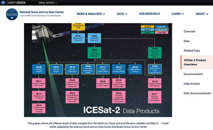
ICESat-2 ATLAS (Advanced Topographic Laser Altimeter System)
ICESat-2 represents NASA's most advanced laser altimetry system, launched on September 15, 2018, specifically designed for measuring ice sheet elevation and surface changes with unprecedented precision. The ATLAS instrument fires 10,000 laser pulses per second, each containing 300 trillion photons, achieving measurement precision of 800 picoseconds. The system provides annual surface elevation change detection to 4mm/year accuracy and can resolve seasonal elevation changes to 10 cm at 17-meter footprints. For Central Asia, ICESat-2 delivers comprehensive coverage of Tien Shan, Pamir, and Hindu Kush glaciers with 91-day repeat cycles, essential for monitoring glacier mass balance and seasonal dynamics.
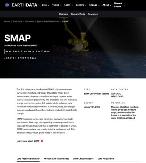
SMAP Soil Moisture & Freeze/Thaw
SMAP provides global soil moisture and freeze/thaw state mapping using combined L-band radar and radiometer observations. The system delivers soil moisture measurements with 0.04 cm³/cm³ accuracy at 10-km resolution and freeze/thaw state detection at 3-km resolution. For Central Asian permafrost monitoring, SMAP offers landscape freeze/thaw dynamics essential for understanding permafrost stability and carbon cycle implications. The mission provides global coverage every 2-3 days, with specialized algorithms for detecting freeze/thaw transitions in complex terrain conditions.

VIIRS Snow Cover Products
VIIRS (Visible Infrared Imaging Radiometer Suite) provides enhanced snow cover detection at 375m resolution with improved accuracy compared to MODIS. The system maintains continuity with MODIS products while providing higher spatial resolution particularly valuable for complex mountain terrain in Central Asia. VIIRS includes enhanced cloud screening and temperature-based quality control to reduce false snow detections. The VIIRS Climate Modeling Grid (CMG) provides global coverage at 0.05° resolution with geographic coordinates optimized for climate applications.
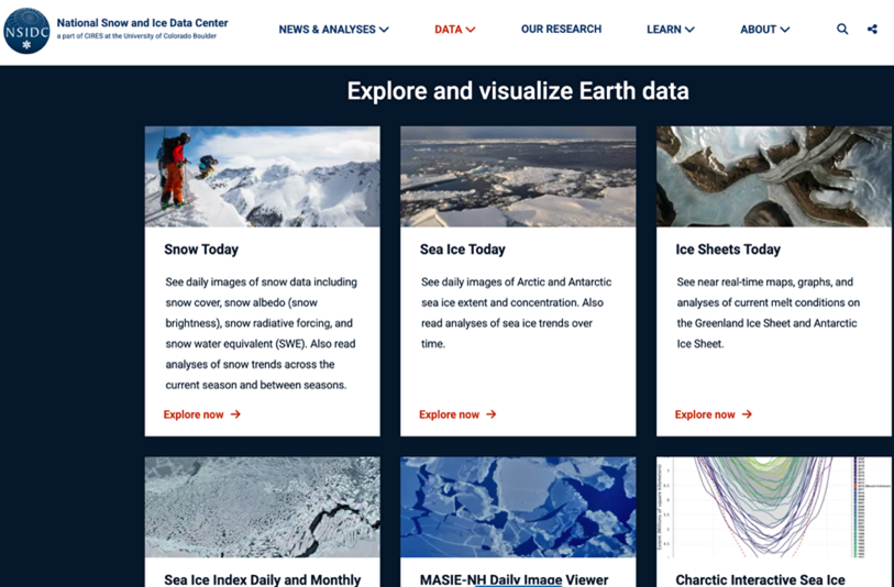
NSIDC Visualization Tools
Interactive visualization, charctic tool, sea ice analysis, glacier viewer
Variable resolution, multiple temporal scales, interactive browsing
Global coverage with specialized cryosphere visualization tools
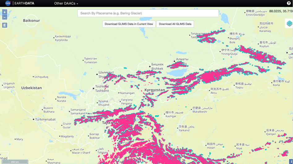
GLIMS Glacier Database
The GLIMS Glacier Database is a global inventory offering detailed outlines and metadata for over 130,000 glaciers, including advanced mapping and data integration tools. For Central Asia, it provides up-to-date, high-resolution glacier boundaries for the Tien Shan and Pamir regions, supporting climate and water resource studies.
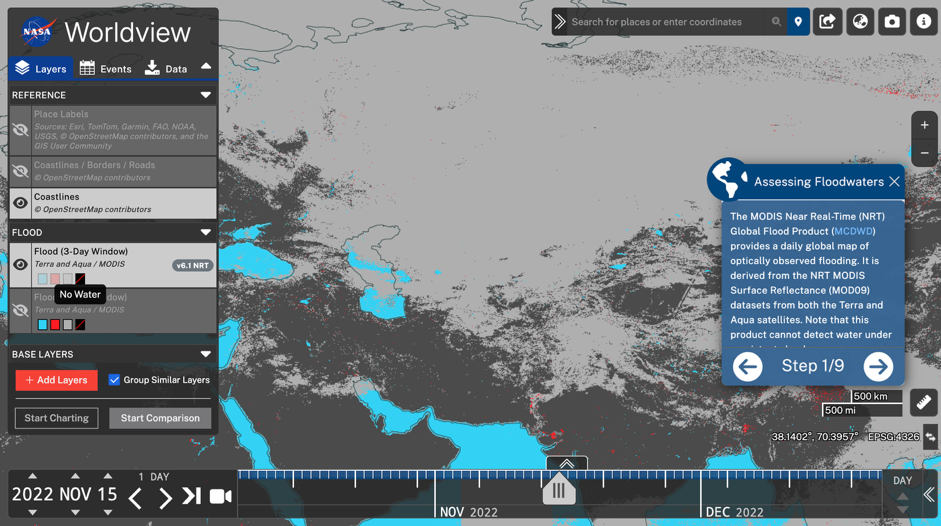
Worldview URL Configuration Analysis for Central Asia
A comprehensive flood monitoring configuration centered on a vast geographic area spanning from Western Europe to East Asia, with particular relevance for Central Asian flood monitoring applications. The configuration is set to November 15, 2022, at 00:00 UTC and includes multiple MODIS flood detection layers alongside reference mapping elements.
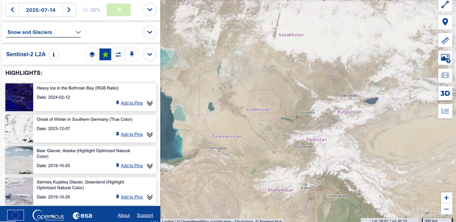
Copernicus Sentinel-2 Browser
Copernicus Sentinel-2 Browser delivers high-resolution, multi-spectral satellite imagery with advanced interactive tools for spectral analysis, time-series visualization, and change detection. Its comprehensive coverage and frequent revisit make it highly relevant for glacier and snow monitoring across Central Asia.
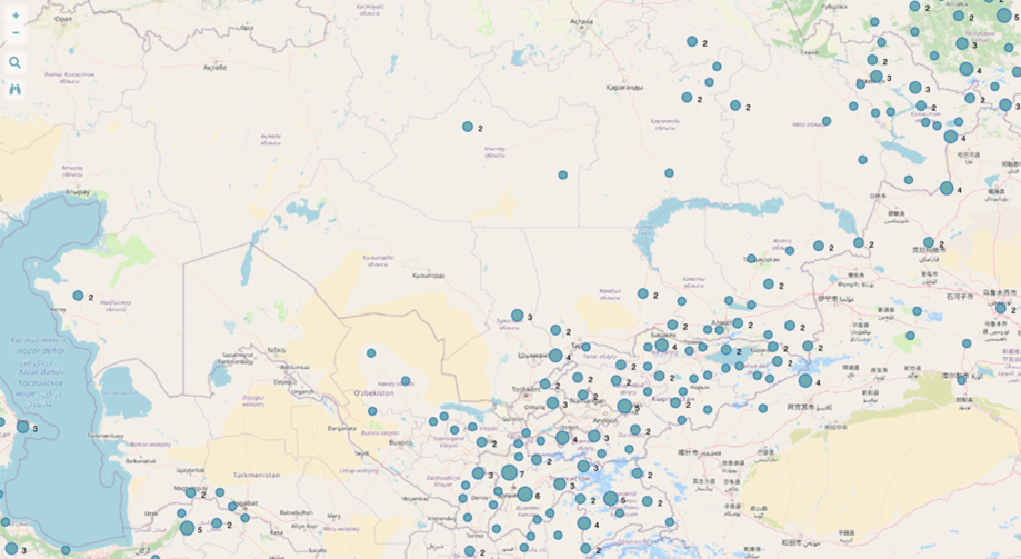
GEO Mountains Observatory Network
The GEO Mountains Observatory Network provides a global database of mountain monitoring sites, including Central Asia’s CAMON network with observatories in Kazakhstan, Kyrgyzstan, Uzbekistan, and Tajikistan. This resource enhances climate and environmental research in Central Asia by offering accessible data and mapping tools for regional mountain ecosystems.
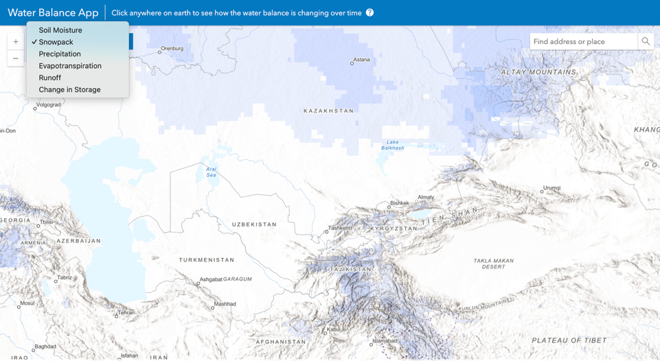
ArcGIS Living Atlas Water Balance
ArcGIS Living Atlas Water Balance uses NASA's GLDAS data to deliver interactive, high-resolution water balance and climate trend analysis globally, including Central Asia. This tool is highly relevant for Central Asia as it enables detailed monitoring of key hydrological variables and trends essential for regional water resource management.
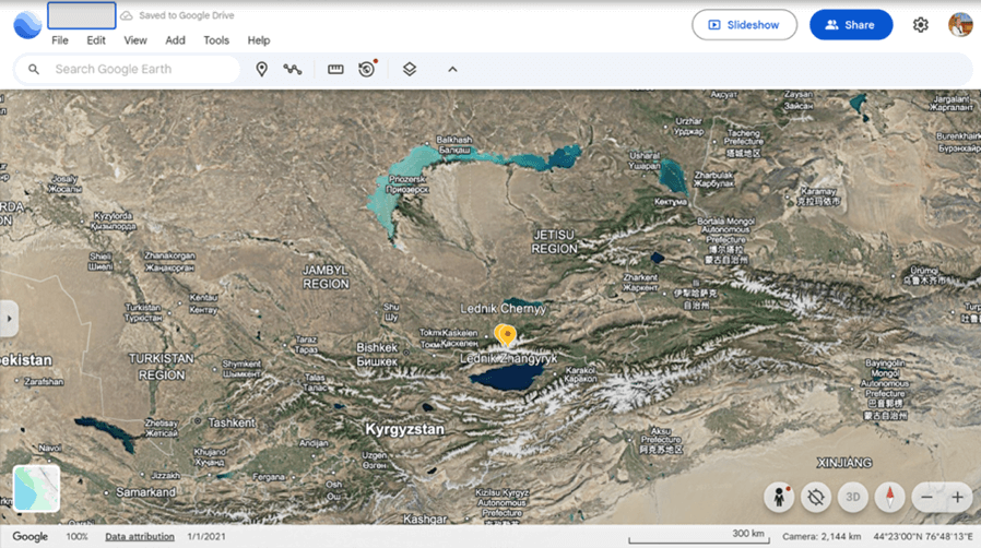
Google Earth
Google Earth provides a full range of high-resolution satellite and photo imagery, including tools for 3D terrain imaging and historical analysis, making the platform an aerospace resource for the dynamics of the Diptychs and seasonal changes in the cryosphere of Central Asia.