Turkmenistan
The Cryosphere of Turkmenistan
Turkmenistan, located in the very heart of Central Asia, is a unique example of a country where the cryosphere is minimally represented, yet plays a critical role in shaping water resources and sustainable development.
The cryosphere of Turkmenistan is characterized by a limited presence of snow and seasonal ice, which contribute to the climate and water resources. The main sources of water are connected to transboundary glaciers. Water resources in Turkmenistan are formed outside the country, fed mainly by the cryosphere of Afghanistan and Tajikistan. Mountain systems play an important role in preserving freshwater reserves. Snow cover also plays an important role in maintaining ecological balance, water resources, and the economic development of Turkmenistan.
Of particular note is the northern part of the country—the territory of Dashoguz, the northern areas of Balkan and Lebap velayats, located in the zone of the Siberian anticyclone. These regions are characterized by harsh and prolonged winters with persistent frosts and snow cover. The winter period as a whole is marked by unstable and variable weather, with frequent fluctuations between positive and negative temperatures. The coldest month of the year is January, with an average temperature ranging from -3.2°C to -4.8°C.

Key Climate Trends
In recent decades, Turkmenistan has experienced a steady trend of increasing average annual temperatures, which affects the water balance, the agricultural sector, and ecosystems.
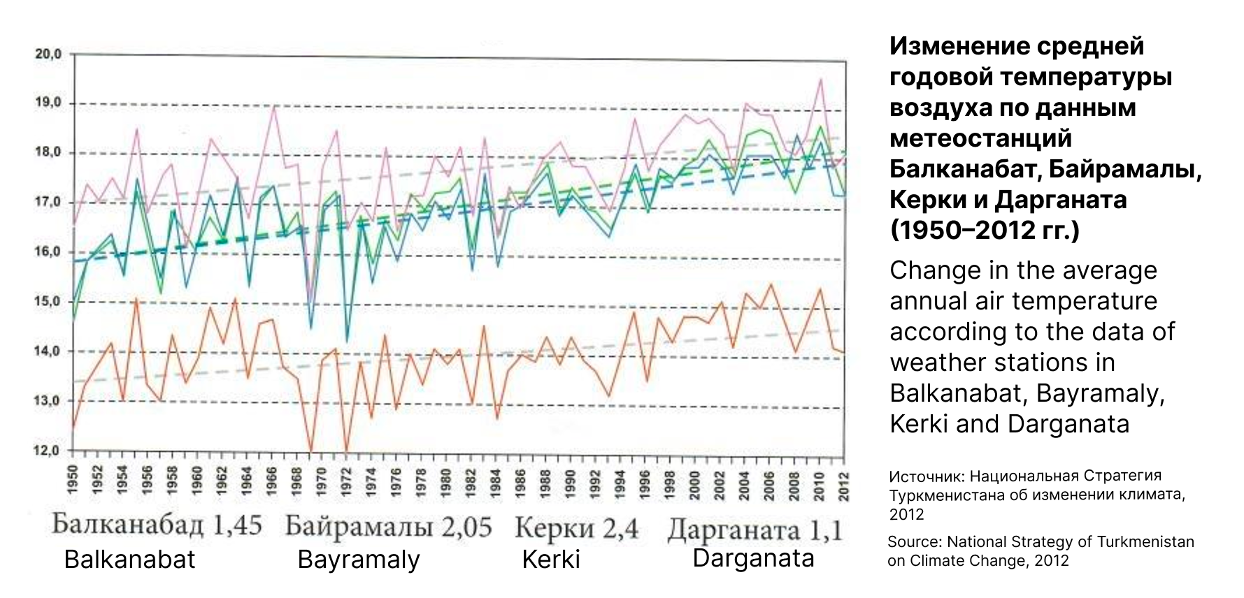
According to the National Climate Change Strategy of Turkmenistan, during the period 1950–2012, the average air temperature increased in all regions of the country, and forecasts to the end of the 21st century indicate a further intensification of this trend. The graph clearly shows a steady increase in average annual air temperatures based on data from meteorological stations in Balkanabat, Bayramaly, Kerki, and Darganata. The trend of temperature rise is especially noticeable in Bayramaly and Kerki, confirming the general warming trend in the region over the past 60 years.
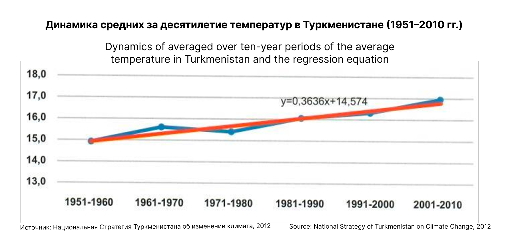
Each subsequent decade was warmer than the previous one. The temperature jump after 1990 is particularly noticeable. The trend line and the given equation (y = 0.3636x + 14.574) show that the average temperature in the region increases by about 0.36°C each decade. This growth reflects processes of global and regional warming, which is consistent with international scientific assessments on climate change.

Analysis of historical data shows periods of low water flow, when the average annual runoff was below normal. The years 1982, 1986, 1989, and 2000 stand out in particular. However, the lowest water years for the entire observation period were 2001 and 2008—66% and 56% of the norm, respectively. This was associated with a seasonal deficit of snow in the catchment area.
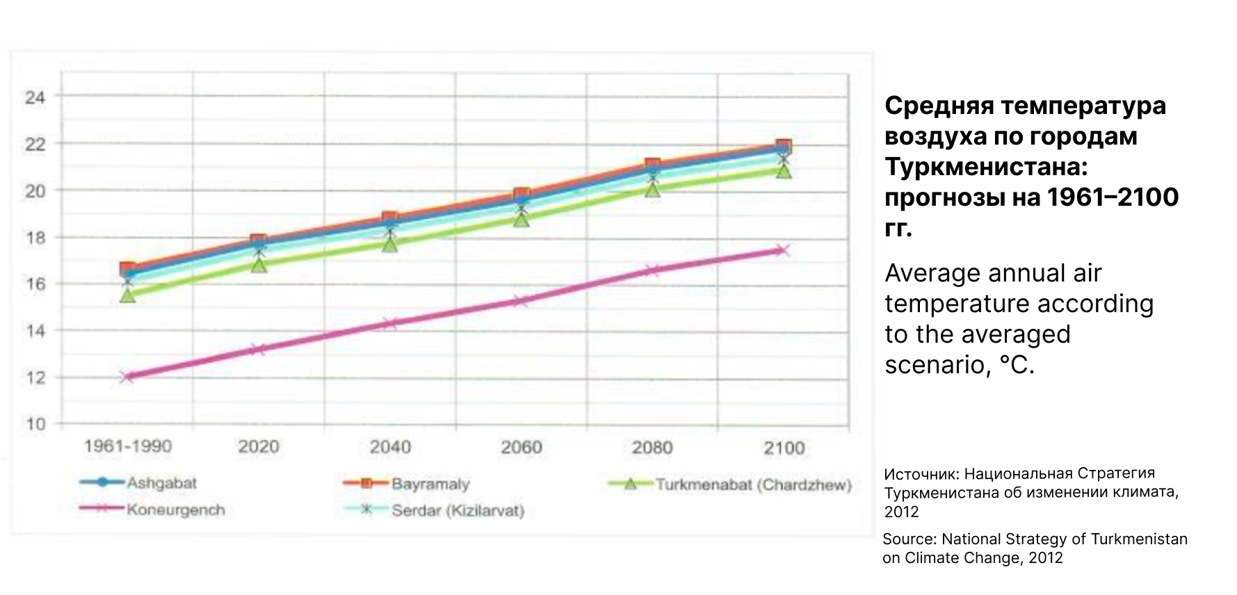
Analysis by major cities showed that by 2040, the average annual temperature in Ashgabat, Bayramaly, Turkmenabat, Serdar, and Koneurgench will increase by about 2–3°C compared to the period 1961–1990. By 2100, it is expected that the average temperature in all these cities will reach 22–23°C, and in Koneurgench—about 17°C.
Thus, in the coming decades, the climate of Turkmenistan will become noticeably warmer, which may lead to increased aridity, higher evaporation, and additional pressure on the country’s water resources. This trend requires the integration of scientific data into national and international adaptation strategies and sustainable water resource management, considering the critical role of the cryosphere in shaping the region’s water balance.